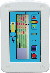
e-Safe
By utilising Ground Probing Radar/Ground Penetrating Radar (GPR) as its underlying technology e-Safe is capable of detecting the likely presence of utility services and other below ground anomalies made from a wide range of materials including those that are non-conductive and/or non-metallic. In addition: Services are not required to be carrying “Live” power, an AC current or, emanat...
..read more
e-Safe
By utilising Ground Probing Radar/Ground Penetrating Radar (GPR) as its underlying technology e-Safe is capable of detecting the likely presence of utility services and other below ground anomalies made from a wide range of materials including those that are non-conductive and/or non-metallic. In addition: Services are not required to be carrying “Live” power, an AC current or, emanating a discernible electromagnetic field, in order to be detectable.
Due to its unique design and easy user interface e-Safe does not require an operator to have extensive knowledge of or, prior training in GPR techniques, in order for it to be used effectively as a pre-excavation safety tool, for the purpose of service avoidance. In order to maintain safety standards and ensure maximum benefit is achieved however; we strongly recommend all operators seek training appropriate to their use and in some countries for particular trades or professions; training is often a mandatory requirement prior to first use.
e-Safe should in most ground conditions; where utility services are found in number, achieve an approximate depth penetration of up to 1.5 metres however; as with all GPR systems, the depth actually achieved will constantly vary according to the subsurface conditions prevailing at the time of use.
In a typical street environment: Pipes, cables or other linear features are often found to run in line with, or directly across the line of the street. Detection success may therefore often be improved by ensuring e-Safe is deployed at right angles to the perceived path within that environment. Where the path of a service is completely unknown: It is strongly recommended e-Safe is deployed in a variety of orientations in order to maximise the likelihood of detection.
Please Note
e-Safe has been designed as a service avoidance tool for use prior to manual excavation works. It has not been designed for the large area mapping of utilities. For this type of use we recommend the PipeHawk e-Spade lite system.
e-Safe+
The e-Safe+ offers everything the e-Safe provides with added Depth Estimation capability. It also features a Chronos Masking Facility featuring 3 Tier Top Down-Bottom Up functionality
e-Safe LOG
The e-Safe LOG offers everything the e-Safe+ provides as well as:
Power On Self Test & Service period Operator notification and downloadable log of functions used and readings taken. Also includes supply of Log Download software & cable.
e-Safe Pro
Designed specifically for those who desire to bring about the eradication of utility service strikes and are therefore looking for the best of the best when it comes to their weapon of choice. The e-SafePRO takes excellence to another level with the introduction of a swathe of new and uprated features. These include 3 different deployment methods “Baseline”, “Syncline” and “Switchback”.
The innovative Chronos Masking feature has also received an update and is now enabled with a more intuitive 4 stage, surface down process.
To the Depth Estimation feature we have now added something we call “TrackBack”.

The biggest change of all however looks you right in the face. The e-SafePRO is equipped with a Progressive 5 lane data View. This means the operator now has the ability to display up to 5 sets of parallel data all at the same time, side by side and in the order of collection.
Baseline
If you collect data using the Baseline method, then your 5 sets of data will be aligned based on a common starting line such as a straight kerb line at the beginning of your data collection. This is the most common method of data collection and can be conducted in either a forward or reverse direction.
Syncline
For those occasions when there is no opportunity to start a series of data collections from a topographical straight edge such as a handy kerb line. Syncline enable the operator to start and end each parrallel data collection (transect) at an unrelated or random point from the preceding one. To ensure each set of data collected can be properly aligned, the operator may choose to mark a known point in each set of data collected. This may be something like a visible tar or scar line in the ground surface. A marked centre or junction line in a highway, or an arbitrary line marked by the operator for the purpose.
Switchback
For those situations where the operator is collecting long swathes of data ie. up to 16 linear metres at a time. Using the Switchback method of data collection enables the operator to alternate their direction of data collection thereby reducing the amount of time the they are simply returning to their common start point rather than collecting data while walking. When you consider some operators may walk anything up to 12km per day, this "return time" can result in a considerable amount of wasted effort.